Sunday 22 June 2008

Leningrad (St Petersburg) - A Trip to the Battlefield - May 2006

 This story must start with an acknowledgement of the horrendous suffering borne by the people of this remarkable city from 1941 through to 1944. One of the victims from the siege was called Tanya Savicheva and her iconic image can be seen throughout the city. Her journal is kept at the St Petersburg Museum of History. My friends Natalya Makeeva and Katerina Stepanova translated some passages for me. The journal has been transcribed onto a powerfully evocative memorial which can be found near the start of the 'Road of Life' to the East of the modern day city.

Inscriptions:
Hzenya (Evgeniya) died on the 28th of December at 12.30 in the morning 1941
Grandmamma died on the 28th of January at 3 p.m. 1942
Uncle Vasya died on the 13th of April at 3 a.m. 1942
Leka died on the 17th of March at 5 a.m. 1942
Uncle Lesha died on the 10th of May at 4 p.m. 1942
Mama died on the 13th of May at 7.30 a.m. 1942
The last 3 sheets: “Family Savichevy is all dead, Tanya is alone"

In August 1942 Tanya Savicheva was taken out of the city to Gor’kovskaya oblast. Tanya was in poor health (because of starvation) and doctors couldn’t help her. She died on the 1st of July 1944. But her brother Michail stayed alive (he was partisan) and her sister Nina also (she worked with a building batallion near Ladoga Lake).

Some 500,000 victims of the siege were buried in the vast Piskaryovskoe cemetery a picture of which I have posted below.


Of course, many people survived and it is a credit to the modern day city that their sacrifice and achievement is still acknowledged today - in particular on Veterans day when the survivors parade through the city.


Leningrad - The City

 This page is devoted to a set of pictures taken within the city limits. Many were taken inside one or other of the excellent military museums.

The picture on the left (below) is of the Astoria Hotel. There is a rumour that the Germans had arranged to have their victory dinner here once the city had fallen. Some say that menus were printed. I found no evidence to suggest that either had any basis in fact. The middle picture shows the Cruiser Aurora decked out for Victory Day. During the siege the ship was moored at Oranienbaum, its mighty guns supporting the defenders of the enclave. It was sunk by the Germans but after the war was refloated. On the right the blue sign in Nevsky Prospekt warns shoppers to walk the other side so as to avoid incoming German fire (it has been left in situ to remind passers by of the black days of the siege).


Some of the following pictures show pieces of Nazi iconography. There are Russian propaganda caricatures of Hitler & Goebbels and uniform remnants from some of the Axis SS Divisions that fought in the area - Flemish, Scandinavian and the SS Police Division. The other photograph shows a Russian soldier removing a German directional sign.


The following pictures show the main War Memorial situated on the main route in from the West quite close to the siege perimeter. The Memorial houses a museum and a quiet place of remembrance. I was struck by the unusual lighting made out of shell cases.


And finally three pictures of artillery pieces. Two  are from the truly fantastic St Petersburg Artillery Museum. The remaining picture was taken on the West of the city at the point where the siege lines were closest to the city centre.


Just stepping away from all things military for a moment - St Petersburg is an astonishing city. Beautiful architecture, terrific museums, vibrant streets and proud people. It could have been so very different had the local populace not held their collective nerve during the war years. As one elderly resident told me "I never doubted that the city would survive. Those that did 'let the lamp of hope go out' didn't survive"


Leningrad - The Oranienbaum Pocket

 On 16th September 1941, 1st Panzer Division and 58 & 254 Infantry Divisions slashed through the Russian lines and reached the coast of the Gulf of Finland at Strelna thus cutting off the Russian 8th Army from other forces defending Leningrad.


With the aid of our friend Natalya we enlisted the help of a couple of people from the private 8th Army museum in Oranienbaum and attempted to drive around the perimeter of the 'kessel'. We ran out of time partly because it was Victory Day and I never refuse the offer of cold meats and vodka from a veteran.  And there were quite a few veterans!


My friend Natalya took the pictures above. During the years of the heroic defence of Leningrad the defence line of Oraniembaum's bridgehead passed here. The inscription reads 'In September 1941 at this site of Oraniembaum's bridgehead the soldiers of the 191st and 48th infantry divisions (part of the 2nd guards division of workers), 2nd division of home guards, students of the navy school for marines, guards of machine-gun & artillery battalions held the line. They were supported by the artillery of the navy ships of the Baltic Fleet (the battleship "October Revolution", battle-cruisers "Kirov" and "Maxim Gor'ky" and other ships. From October of 1941 till May 1943 the soldiers of 48th division held this line, later until January 1944 the 168th infantry division fought here'.


The pictures above were all taken on the East side of the pocket around Gostilicy where the T34s massed before the final breakout in January 1944.

The enclave which was 20 miles long and ten miles wide held out throughout the siege. Kronstadt provided a lifeline for supplies and a safe haven for supporting heavy artillery.


Pictures from left to right. First - veterans, a school delegation from East of the Urals and myself enjoying vodka and "authentic soldiers food" (the former was much more palatable than the latter). Second - a map showing the breakout and liberation of Peterhof and third - veterans enjoying a lunch in the field.


Pictures from left to right. First - gun positions on Kronstadt Island. Second - Peterhof Palace destroyed by the retreating Germans. Third - Peterhof spectacularly restored.

The attack by the 2nd Shock Army from the Oranienbaum enclave on January 14th 1944 supported by the guns of the Baltic Fleet was a key factor in the eventual lifting of the siege. Today Oranienbaum is called Lomonosov and this part of the battlefield is easily accessible by bus or car from Peterhof or by local train from Peterhof and St.Petersburg.

Leningrad - The North

 The Karelian Fortified District (KaFD) existed from 1928 as a line of defence for Leningrad from the north (Leningrad was only 30 - 50 kms from the border). It played a pivotal role during the period 1941-1944 when the Finnish army approached the city from the north. After WW2 the KaFD didn’t lose it's role: from the end of the 1940s and until the middle of 1950s intensive rearmament and building took place.


The Fortified Districts contained one line of fortifications from 3 to 5 km depth. In places a second fortified line was constructed at a depth of 10-15 km from the first line. Special attention was given to the construction of anti-tank defences. The builders used anti-tank ditches and took advantage of the prevailing topography.


The most common type of pillbox in the area was a small construction with 2 or 3 embrasures. All were one-storied, 8 to 9 metres long and 6 metres wide. The thickness of the wall was from 1 metre to 1.5 metres covering an area of 12 - 15 square metres.

Large pillboxes were slightly less common. These had from 3 to 6 embrasures and were two-storeyed. These constructions sometimes covered an area of up to one hundred sq.metres. These larger types often have two exits plus in addition to the main entrance.

The pillboxes with thicker walls could withstand several hits from 203-mm shells or a few hits from 280-305-mm shells. The pillboxes with thinner walls could withstand several hits from 152-mm shells and a few hits from 203-mm shells. Inside walls and ceilings were originally covered with steel, five to seven mm thick.

Pillboxes had a very wide arcs of fire – not less then 180 degrees. Pillboxes with 6 embrasures had arcs of fire of 360 degrees. There were stores of food and water in pillboxes and smoke and gas filters for ventilation.

There was electricity in all the pillboxes and stoves for heating & cooking in bigger ones. There was no sewer system in most of them, buckets with waterproof covers were used. There were telephones and radio stations (in the bigger ones) and speaking tube for interior communication.
Machine-gun pillboxes were located 300-500 m far from each other. Buried MS-1(T-18) tanks were used like additional weapon emplacements. 160 written off tanks were given to the Leningrad district in 1934-1937.

After the war there was no further construction in the KaFD. However, there was some modernization of equipment and arms in 1950-1955 and the ventilation system was improved. In the beginning of 1960s all of the buildings were closed down and the machine-guns were taken away.

The photographs below show the memorial complex at the Lembolovo Heights Note (actually the name 'Lembalovo' is more exact in historical terms because in 1920-1950 it was used).


The complex is located 31st km from the Priosersk arterial road. These heights were originally the scene of a series of battles during the 1918-1920 conflict when soldiers of the Red Army succesfully fought against the White Army. In commemoration of this feat a small granite plate was installed here.

In 1941 the divisions of 23d Army and several Brigades of Seamen - Frontier Guards fought against the Fins here. my friend Natalya says that "On the 6/09/1941 they stopped the fascist divisions here and didn’t let them pass to Leningrad".

She went on to say "From this site the deliverance of the Karelian Isthmus began in 1944. The memorial complex was built on the site of the former front line of defence and the memorial symbolises the courage and the bravery of the victors".

The inscription on the stone (far right) translates as follows: 'This time was lost from us but now it stays with us forever'(Boris Lavrenev, Russian writer).

The architects of this memorial complex were Yu.Tsarikovsky, B.Svinin, N,Sedov. Sevent nine enterprises from the city participated in it's construction.

Leningrad - Siniavino and the South East

 Below the Siniavino heights there is a strip of marshy land which extends to the shores of Lake Lagoda. It was through this strip that the 123rd Rifle Division, 67th Army and the 372nd Rifle Division of 2nd Shock Army fought in order to link up thus breaking the siege on January 18th 1943.


Julia, Mark & I were lucky enough to spend an evening with a veteran (Nikolay Vasipov) who was in this area in the action from the 20th January. Tears welled up in his eyes as he recounted travelling along the North/South road beneath the Siniavino Heights. "The trees were smashed and the air was thick with smoke from the burning peat. The Germans had constructed a road through the marshes. It was an inferno and I found it hard to ignore the cries of the wounded echoing through the smoke and the trees. It was hell on Earth".


On the lip of the Siniavino Heights there is a large memorial and a number of graves including some very recent ones. We shared a drink with some Russian soldiers who were exhuming battlefield casualties and reburying them. The Russians refer to the people who are excavating the battlefield as white and black 'diggers'. We saw plenty of both kinds. The latter are best avoided.


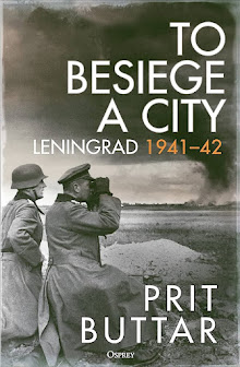
At the first moment of crisis when the Germans had almost surrounded Leningrad in September 1941, Zhukov briefly stepped on stage. He stiffened resolve and stabilised the front. With his usual elan he launched a counter attack across the River Neva. The resultant bridgehead was held throughout the siege. Today it is a bleak desolate place, covered in the detrius of war, fresh graves, and evidence of the work of 'black diggers'. One can walk around the bridgehead in an hour easily discerning the front lines and strong points. Amongst the memorials one can find a T34 tank and a symbolic representation of the destroyed hamlet of Nevski Dubrovska. A sad place.


One of the reasons the Russians hung on so tenaciously at the Nevski Bridgehead is the proximity of the important railway junction at Mga. The day we visited Mga it was sunny but it was difficult not to be effected by the squalor of the place. A statue of Lenin dominates the decaying properties in the centre of town. The station, with its memorial plaque, was full of sleeping servicemen and drunks. A stark contrast to the stunning city of St Petersburg an hours drive away.


Top three pictures are Mga with the station in the centre. The bottom three are of tanks recently pulled out of the River Neva and restored by local enthuasiasts. The tanks can be viewed on the river bank near the settlement of Mar'ino.

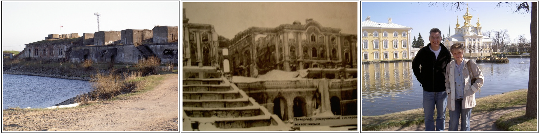
Some way South of this area one can find the massive German Cemetery at Sologubovka. 80,000 burials in a picturesque location next to the recently restored church. Its isolation means some graves have been personalised. There are controversial memorials such as one dedicated to the men of Flanders who served with the SS (which had been broken and subsequently restored).


And finally - the stunning diorama at Mar'ino near Kivosk. This is located at the heart of the Memorial Complex housed in and near the ramp of the Lagoda Bridge. It commemorates Operation Iskra (spark) carried out between January 12th and 30th 1943. The 67th, 2nd and 8th armies broke the blockade linking up at the Workers Settlements numbers 1 and 5, Rabochy Posyoloks. The painting is by a number of local artists. Some of the panels are shown below.


It was in this area that the fate of the city of Leningrad hung for several long years. My friend, the veteran - Nikolay Vasipov, told me that he never lost faith in victory. Here is a summary of his war service.
Born in Leningrad and left school at 14 years old. The opening day of Barbarossa (22nd June 1941) was a warm day - he remembers a band playing and everyone being happy. He remembers hearing news of the invasion on the radio and noticing a wind blowing.

Three days later he enlisted and after two weeks training was sent to help build an airfield at Schisselberg. He was there for three months and remembers people being shopt for being in possession of propoganda leaflets dropped from German planes.

There was no panic in Leningrad as the Germans approached - "the city will stay ours". Joined the 34th Ski Brigade, 67th Army. Remembers Zhukov arriving and making a difference "straight away". He says Zhukov cancelled an order to sink the fleet and exercised cruel authority.

Nikolay remembers the liberation of Schisselberg (the population would have preferred to stay under the Germans he says). He says that the remaining population of this town were taken to Leningrad and shot by the NKVD. Nikolay says the Germans 'lost heart' towards the end. He remembers a skinny Russian boy capturing two ruddy faced SS men.

After Leningrad Nikolay he joined Rifle Regiment number 51 and went to Lvov in the Ukraine by train. He remembers the decision to let the Breslau defenders out of the Kessel and ended the war clearing basements near the Berlin ring road. He ended the war facing the Japanese in Manchuria. Today this proud man lives with his delightful family in the suburbs of St Petersburg.

Leningrad - The German Fortified Areas in the South

 Ropsha is a small town to the South West of St Petersburg. During the siege it was an important hub for the German Army. One of the major siege batteries was stationed in the grounds of the chateau. To the South East was the fortified enclave of Gatchina where Von Leeb (the German commander of Army Group North) had his headquarters. East of Ropsha one can still admire the city of St Petersburg from the Pulkovo heights where the Germans caught their first view of the city in September 1941. 


The gun pits in the chateau grounds are still viewable beyond the trees below the tank memorial. Prior to my visit I had been struck by picture of a small church at Ropsha. It carried the title 'A red army convoy drives past the ruins of a church at Ropsha. It had been used as a place of worship by the Wehrmacht during the siege'. With the help of our good friend Natalya Makeeva we found the church and uncovered a sad story.


The top picture on the shows Ropsha Church as a Lutherian place of worship immediately following liberation. The picture underneath shows the wrecked church now surrounded by Russian war graves. I met a veteran in Lomonosov who showed me an article which sheds some light on what happened in this tragic place. The text is translated below.

'According to old Ropsha residents the Germans built their cemetery on the site of a Russian one - reinterring the bodies elsewhere. Amongst the German soldiers buried at Ropsha was a man called Christian Peterson, A Lutheran (his grave marker is circled in the article). The Russians broke up the grave and a soldier called Sergey Krestyanov was buried in the same plot. Much later Peterson's relatives from Australia visited the site and put an oil lamp on Sergey's grave in commemoration of the previous occupant of the plot. The Russian people have since left it there as a gesture of reconciliation'.

We had hoped to get to Krasny Bor where the Spanish Blue Division fought its last action in February 1943. Sadly, we encountered mechanical problems with our car but, nevertheless we did get to Kolpino where the 72nd Izhorsky Battalion had blunted and stopped the main German assault from the South in late 1941. The workers from the Izhorsky Tractor (latterly Tank) Plant had taken weapons and marched out to face the enemy whom they stopped dead a few miles south of the factory gates.


Taking the road from Kolpino to Gatchina is a good way of tracing the German siege line in the South. At one point the front line is marked by a series of white triangular markers. The area has many Russian cemeteries and memorials.

My thanks goes to Natalya Makeeva who introduced Mark and I to the ancient Russian custom of blagging a lift from any passing car. In Russia every car owner in the countryside is a potential taxi driver! Most were astonished that we wanted to go to the middle of knowhere to look at old trench lines, bunkers, etc. We made it back to the airport JUST in time!

Gallipoli (1915) - Anzac & Suvla

God has been kind to the Gallipoli Peninsula. In 1915 it was the stage for suffering on a massive scale but nowadays it is a place of beauty. We visited in May and the place was a picture of perfection. Turqoise water, blue sky, vibrant colours, lush vegetation and an abundance of wildlife. At first glance one has to concentrate hard to remember that this place is sacred ground. The peninsula is now a National Park and is therefore spared the development that has blighted so many battlefield sites.


Anything more than a cursary glance instantly reveals a dark history to this lovely place. Rusting fortifications, beached hulks, scarred earth, trenches and, of course, the cemeteries. The allied CWGC sites - well documented and perfect to the last detail. The Turkish sites - immaculate but without the rows of names that are the poignant legacy of allied sacrifice.

The two principal Anzac beaches are hinged at a small outcrop (known by the diggers as Hell's spit) which juts out between the stretches of sand. It is here that the beautiful Beach Cemetery can be found. You don't need a map to quickly identify the surrounding topographical features; Plugge's Plateau, The Sphinx, Russell's Top and Walker's Ridge. The climb up to Plugge's Plateau is hard going but the view from the Cemetery at the top is breathtaking.


We were keen to see Shell Green Cemetery. I'd seen photographs of cricket matches being played out here (under shellfire) in 1915. Now the players lie in serried ranks carefully delineated by name, rank and number. The photograph of the young Australian above was found blowing amongst the flower beds at Shell Green. I presume he's buried there. I left the original and took the above copy.


Chunuk Bhair was the key to Anzac and the view is fantastic. To get there it is necessary to take the road up along the old front line. The trenches are stll there - tucked into the reverse slope on the edge of the escarpment. Lone Pine, Johnson's Jolly, German Officer's Ridge, Courtney's, Quinn's Post, Bloody Angle, The Chessboard, Baby 700 and Battleship Hill. There's a veteran's recollection in the IWM archive where a digger talks of sitting up on the ridge watching the battleships firing at the Turks; "sort that one out amongst yerselves, yer bastards" he mutters as a huge shell whistles overhead towards his foe. It must have been so demoralising when the ships steamed away following the recall of the fleet in the Autumn of 1915.


The road up to Suvla is marked by a series of CWGC cemeteries. 7th Field Ambulance looked beautiful framed by a field of poppies in the foreground. We passed the three freshwater wells which had proved so critical during the battle, travelled up to Hill 60 where the fields are full of shrapnel and on to the salt flats where Stopford's IX Corps landed (and went no further) on the 6th August 1915. Our journey ended in the peaceful tranquility of Lala Baba, Hill 10 and Azmac.

Gallipoli (1915) - Helles and the Narrows

The place to start with this battlefield is amongst the guns. Many have gone - the monsters mounted on ships like Majestic, Prince George, Ocean, Agamemnon, Inflexible, Vengeance, Irresistible, etc. But ashore there are many - in the forts on the peninsula, on display in towns like Cannakele, on the clifftops on the Asian side of the Straits and amongst the vegetation of the battlefield.


The Turkish memorial in the centre below commemorates Seyit Onbasi who, through an act of bravery, enabled a direct hit on HMS Ocean. The Turkish authorities are beginning to refurbish some of the old forts as tourist attractions others remain derelict and are, in my opinion, MUCH more interesting! Careful though - the modern day Turkish army still has a presence on the Peninsula so best leave your camera in your bag.


We took a day out with my friend Eric Goossens (picture below on Gully Beach). Eric runs a really homely tourist hotel on the peninsula and is passionate about the 1915 campaign.  The Gully is hard going but well worth effort. Start at Gurkha Bluff and follow the ravine south to X Beach. At the mouth you'll find a well dug by the Royal Engineers and the remains of one of the evacuation ships which was beached and stranded on the night of the 8th/9th January 1916.


One of the highlights of the trip was our exploration of Observation Hill - just North of Skew bridge cemetery. Here we found (with a little local help) this incredibly well preserved Royal Naval Division dugout. The area around the Eski Defence Line is covered in trenches - well preserved because they were carved into stone and rock.


Eric took us down to three cliffside bunkers at Cape Helles. Above them one can find two big water tanks built in 1915 by men of the Monmouthshire Regiment. The picture below right shows me sitting under the Duckworth Oak in Redoubt Cemetery. 2nd Lieutenant Eric Duckworth, B Company, 1/6th Lancashire Fusiliers was killed in action at the Vineyard on the 7th August 1915. His father planted the oak after the war. 


The area around V Beach is full of interesting features. Apart from the batteries and guns there are a number of really impressive memorials. It's a straightforward walk from Seddulbahir down to the beach and easy to make out the spot where the the HMT River Clyde was grounded. The terrible ferocity of this battle is illustrated by V Beach Cemetery which sits right on the waters edge.


Nearby one can visit Hunter Weston Hill, site of the VIII Corps HQ and Doughty-Wylie Hill the lonely burial site of a holder of the Victoria Cross. These features are framed by the blue water of Morto Bay where, on the night of the 12th May, 570 sailors lost their lives when HMS Goliath was sunk by a Turkish Motor Torpedo boat. 


We reached Lancashire Landing (W Beach) on a warm evening - the sun was dropping, the sea was shimmering and a lone fisherman was casting his net from a boat. A far cry from the scene at that same spot on 25th April 1915 when the 1st Battalion, Lancashire Fusiliers won six VCs 'before breakfast'. There is much to see - the shoreline is marked out with rotting pier stanchions and beached boats.


It is here, near Tekke Burno that HMS Majestic was sunk on the 27th May 1915. The ship was sunk by a torpedo from U21 a German submarine. She settled in 16 metres of water and veterans recall that the old battleship looked like a beached whale.


Helles is a fascinating battlefield. Overshadowed in popularity by Anzac to the North, it is a relatively undiscovered treasure trove for anyone interested in the history of the Great War. Go there - you won't be disappointed!

Vietnam - A Trip to the Indochina Battlefields - October 2005

 The evidence of Vietnam's post 1945 wars pervades the whole country and yet every Vietnamese person I met seems to have a genuine affection for 'the West' and a real desire to assimilate many aspects of Western culture. The country is a stunning mix of different cultures, dispirate landscapes and eveyone is embued with a deep nationalistic pride. The iconic picture of peasant soldiers (below) can be found in Hanoi's excellent War Museum.


The T54 tank pictured in the middle picture below is the very same tank that burst through the gates of the Presidential Palace in Saigon during the final act of the Vietnam war in the early summer of 1975. The tank is now in the Hanoi War Museum. The Palace in Saigon has been left as it was in 1975 with the original campaign maps showing the disposition of South & North Vietnamese forces still in place in the various underground command and control bunkers. The photos 'Huey on Palace Roof' and 'Plane - Saigon' (below) show the aircraft which bombed the Palace in the final stages of the war. The pilots were, I believe, defecting South Vietnamese.


The wreckage of a B52 and other aircraft pictured below can be found in Hanoi, a city heavily bombed by US forces. I visited the infamous 'Hanoi Hilton' prison - or what's left of it. There is an exhibition showing how well the American pilots were 'looked after' (sic). The site is called 'Maison Centrale' and is near the 5* Melia Hotel. The destroyed American tank pictured on the right can be found in the Ben Luc area South West of Saigon (now called by some 'Ho Chi Min City').


I found the Huey (below right) languishing in an old colonial army base in the city of Can Tho. This aircraft really evokes the spirit of the times and I found examples in Saigon & Hanoi as well.


The Cu Chi tunnel complex near Saigon is now a tourist attraction. The tunnels stretch for 150 miles to the Cambodian border in the north down to near Vinh Long in the South. I went down into the blackness and found it an uncomfortable experience. Watching locals demonstrate the horrible traps and seeing the evidence of American bombing I found myself thinking how significantly circumstances have chaged in Indochina. The middle picture below is a man trap concealing huge lethal spikes made out of bomb remnants.


The country is dotted with VietCong war cemeteries and memorials. The one shown on the right below is near Vinh Long in the Mekong Delta and is a concentration plot. Amongst other casualties, it contains 300 Viet Cong killed at Tran Yan Be on the 16th October 1969. These particular graves were moved from their original location to make way for the Dong Phu Secondary School. A picture of the massive memorial at the Ho Tri An on Route 20 in the South Highlands is shown top right - 'Fishing'.


The South Vietnamese and American flags (above middle) can be found tucked away in Saigons grisly War Museum.  Below from the left: Road Bridge destroyed by the Americans at My Tho, 100mm shell used as an air raid warning in central Hanoi (near the Ho Chi Min heritage site) and American pilots helmets in Hanoi.


There is still a stark difference between the 'free-wheeling' South and the austere North. Go and see - it's a fantastic country with the warmest, friendliest people you could expect to meet anywhere.