Pages

Saturday, 18 December 2010

Demyansk & Cholm (1942)

I've been fascinated by the encirclement battles at Demyansk and Cholm ever since my trip to Volgograd (Stalingrad) a few years ago. A few friends and myself had the opportunity to tour the Stalingrad battlefield and meet Russian and German veterans in a city where, in the winter of 1942/43, the German 6th Army was totally destroyed.

The delusion that Goering would be able to supply over 300,000 men by air until Manstein was in a position to break a corridor through to the beleagured city is one that is difficult to rationalise. And yet the rationale at the time was that there was a powerful precedent - Demyansk.


At Demyansk 6 Divisions of the German 16th Army consisting of 100,000 men held an area of 1,200 square miles for 12 months and 18 days. A smaller group of 5,500 held out at another critical piece of high ground at  Cholm. Supply was maintained by several hundred aircraft making daily flights and the successful defence of these 'Kessels' enabled Army Group North to stabilise a battle front which had come near to collapse following Zhukov's momentous counter attack after the ill fated German decision to push for Moscow in the winter of 1941/42.


So, next May with the help of a Russian friend, I will be leading a series of battlefield walks which will retread the steps of Von Leebs' 16th Army through Novrogod and Staraya Russa up into the Valday Hills and then onto the area where these two encirclements happened. The tour is pretty much fully subscribed but I'll be sharing details and photographs from the trip soon after I get back. The Cholm/Demanysk walks are the third in a series focussing on the northern front of the 1941/45 Russian/German conflict.

If you would like to read more about the 'Army Group North' battlefield walks mentioned in this post, they can be accessed through the links below.

The Siege of Leningrad
The Narva Bridgehead

Saturday, 6 November 2010

Operation Husky, Malta in 1943

My chosen reading for a recent trip to Malta was 'D Day' by John Gunther. Not, as you might imagine, a book about the Normandy landings in 1944 but actually an eye witness account of the assault on Sicily in 1943 - Operation Husky. By a happy coincidence my wife and I found ourselves staying at the Hotel Phoenicia, the same hotel which was used by the author during his visit to the war torn island of Malta. For it was on the island of Malta that the operation was planned.


A short walk from the Hotel and quite close to the RAF Memorial, one cannot miss the huge medieval bastions surrounding the old town of Valetta. It was below these city walls, at the foot of the Lascaris Bastion, that Eisenhower planned the invasion of Sicily.

I'm told that the site is about to be turned into a tourist attraction. However, I was lucky in getting to see this historic place in its 'natural' state. Gunther recalls going down into the tunnels to what was known as '947' and meeting the General in a room that he described as a 'cubby hole'. Some 67 years later and after negotiating my way through a series of tunnels and  rubbish strewn passageways, I was able to identify vestiges of the original military presence. The following photographs show the complex as it is now.

Monday, 6 September 2010

Stirling Bridge (1297), Falkirk (1298) and Bannockburn (1314)

They say that you can see thirteen battlefields from the top of the Abbey Craig near Stirling - the gateway to the Scottish Highlands. Last weekend I visited three of them. In the fourteenth and fifteenth century the only sensible route to the north was across the Forth at Stirling and up through the valley beyond. So, when Edward 1st sent a formidable English Army to consolidate his hegomony over this previously independent country, William Wallace and Andrew Moray chose this spot to give the invaders a bloody nose.
In a tactically brilliant action Wallace (Left) and Moray let part of the heavily laden English army across the bridge and then attacked - cutting off their forces on the North side of the river. Floundering in marshy ground and faced by a ferocious albeit small Scottish Army, the English were severely beaten. Of the English commanders, The 7th Earl of Surrey (John de Warenne) survived but Hugh de Cressingham lost his life to Wallace wielding a huge double handed sword. The sword can still be seen on the first floor inside the Wallace Memorial (see picture above) on the bluff where the Scots laid in wait for the English.
This astonishing feat of arms has little in common with the portrayal of the battle in the film 'Braveheart' though I would imagine the rhetoric and demeanour of the Scottish troops is probably quite accurate.

Saturday, 21 August 2010

The Grand Harbour, Malta


Family holidays often present an opportunity to follow through on my interest in military history. Earlier ths year my wife and I took a trip to Malta. The Grand Harbour was for many years the home of the British Mediterranean Fleet and I know from old documents held in my family archive that a relative of mine had been based on the island at the turn of the century.

Amongst Ernest's legacy of photographs and documents, I have a picture of HMS Commonwealth steaming into the Grand Harbour, Malta. Luckily for me, my wife was keen to go on a Harbour Cruise so I took the opportunity to take the photo shown below. Same location as the top photograph but with a 100 year time difference.

Saturday, 24 July 2010

V Weapons on the Cotentin Peninsula (1944)


Had the V1 bases at La Sorellerie and L'Orion, near Cherbourg, become operational then the city of Bristol would have been within range of these terrifying weapons. The successful allied landings in Normandy from June 6th 1944 meant that this scenario never turned into reality. Both sites are complete though neither were actually used in anger.

The sites can be found, albeit with some difficulty, approximately five miles south of Cherbourg on the Contenin Peninsula. We had just about given up trying to find them - having found just a single hard structure for housing a mobile searchlight battery. Luckily a local farmer came to our rescue and we were able to visit most of the buildings that make up the L'Orion site - though frustratingly, we weren't able to find the primary 'ski' ramp.

The pictures above show (top to bottom) the main command bunker, a V1 storage tunnel (heavily camouflaged and impossible to find without local help), a gun pit on the site perimeter and a building housing two V1 maintenance bays. There is evidence of heavy bombing in the vicinity but these buildings have survived well - most probably because they are well protected by earthworks and are tucked away in a natural fold in the landscape.

Tuesday, 22 June 2010

Leningrad - The Corridor of Hope

 Today the road from St Petersburg to Ladoozskoe Ozero is an easy one (apart from the need to negotiate your way through the contractors vehicles parked up on the site of the yetto be completed ring road).  Taking the A103 one passes the Finland Station before heading off down a route which was, in essence, a lifeline during the siege years. The road is delineated by markers (see marker number 41 below) and memorials. At the end one reaches a simple memorial gateway on the shore of Lake Lagoda by the side of which there is an anti aicraft gun still pointing at the sky above the old 'ice road' (right below).


Despite the early onset of warm weather, ice was still present on the margins of the lake when we visited at the end of May (picture left). The picture in the middle shows the start of one of the main routes for the 'ice road'. Pictured left to right - Vladimir, Mark , Julia and myself.

The story of the Ice Road is remarkable and I don't intend to recount it here. However at the St Petersburg Artillery Museum I did find an excellent picture of Russian KV1 tanks crossing the lake (see below). A veteran told me that when the ice thinned the turrets would be taken off to lessen the weight. The drivers must have had some guts!


The first train through to Leningrad after the siege was broken is on view near M'ore on the lake shore. I grabbed a picture just as a modern train sped through. The picture on the left is an idealised image of the first journey.


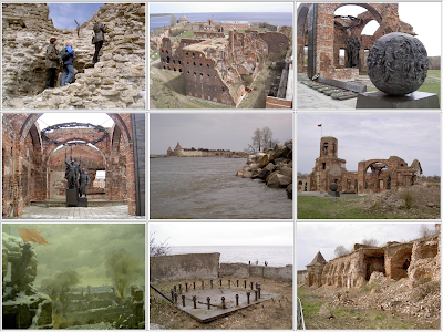
Of course the whole outcome of the battle would have been different had the XXXIX Panzer Korp swung north and crossed the Neva river after 20. Infantrie Division took the lake side town of Schlusselburg on the 6th September 1941. I had been very keen to visit this pivotal location and in particular to see the island fortress called Oreshek (the Nut). Following a heroic action by just 12 Russian sailors the fortress, the garrison of which was subsequently reinforced, held out from September 1941 through to the breaking of the Leningrad encirclement in January 1943. After negotiating a passage across 500 metres of freezing water I was able to take some remarkable photographs of the place.  As can be seen, it wasn't easy to get in but my thanks go to Julia who helped Mark, Julia (our guide) and myself to climb in.


The red flag flew from the smashed tower at Oreshek throughout the siege and flies on the ruins still. A remarkable place and one of the most resonant WWII sites I have ever visited.

Friday, 11 June 2010

Tiger at Vimoutiers (1944)


There are many WWII relics in Normandy today and one of the most impressive is this Tiger which can be found close to the spot where it was abandoned during the German withdrawal in the summer of 1944. The tank is believed to be from Panzer Abteilung 503. On the 19th August 1944 several tanks were making their way towards a fuel dump set up at the Chateau de L'Horloge having extracated themselves from the Falaise Pocket. This one probably ran out fuel and it is known that it was bull-dozed into a roadside ditch on the Vimoutiers to Gace road (N179). Many years later, in May 1975, it was recovered and restored.

Saturday, 20 February 2010

Bristol Air Defence (1940 - 1944)


Between 2nd November 1940 and 15th May 1944, Bristol was subjected to a series of bombing raids. Six of these were on a huge scale, causing considerable damage across the city. During the period 1,299 civilians were killed. Over 85,000 properties were destroyed with much of the city centre, including 6 historic churches, suffering total wipeout.


Rockingham Farm HAA Battery, Portishead
Purdown HAA Battery, Bristol


The main defence against air attack was heavy anti aircraft artillery. Today, it is possible to visit the sites of some of the key batteries. One of the most famous was the 4 gun heavy battery on Purdown Hill. The third picture above shows the mountings in No. 1 gun emplacement. At the time of visiting the site was in a disgraceful condition. The emplacements are behind wire as is the ammunition store (though the latter can be explored with a little ingenuity). Eye witness accounts tell of 'Purdown Percy' making a cacophony of noise as the heavy anti-aircraft guns opened up on incoming Luftwaffe aircraft.

The Purdown Battery (Adam Kertesz Photography)

236 Battery, 76th HAA Regiment at Portbury

The top two pictures are from the site of Bristol No.2 Heavy Anti Aircraft battery which can be found close to the town of Portishead. The battery was sited on the coastal plain with good line of sight over the port complexes at Portbury and Portishead.  There is much to see on the site today. The original sentry box & guard house (albeit 'augmented' by post war camouflage paint), the ammunition store, 4 numbered gun positions, deep bunkers and the vehicle store with inspection pit. Remarkable that I've only just found this facinating site which is just a few miles from my home.


Many of the casualties from the Bristol bomb raids are buried at Greenbank Cemetery in Fishponds (above). The top picture shows a plot dedicated to civilian victims of the bombings. It is a poignant place. The military casualties are buried nearby in a separate plot - British, Commonwealth, Italian and Polish alongside German aircrew shot down in the Bristol locality.