Wednesday 28 October 2020

The Big Guns of Fort Ino / Fort Nikolaevsky - Russia (1906-1920)

A couple of years ago I was persuaded to take a road trip from St Petersburg to Helsinki looking at sights associated with the Winter War 1939/40 (not that I needed much persuasion!). It proved to be a fascinating journey and I was astonished to discover how much remains of the various conflicts which have been played out across the strategically important Karelian Isthmus. The Mannerheim Line is relatively well known to most Western based military history enthusiasts but the static defences built to protect St Petersburg, the old capital of Russia, are less well known.

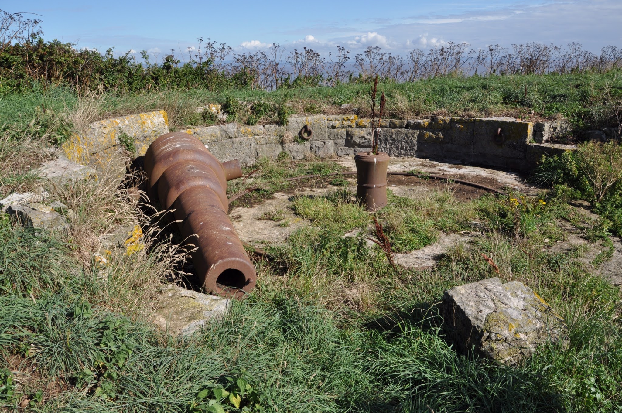
Gun Emplacement - Fort Ino

One such site is Fort Ino (as it was known by the Finns) on the northern side of the Gulf of Finland, a key lynchpin of the shore and island based batteries covering the approaches to the important Russian naval base at Kronstadt. Now in Russia, during its brief operational life it was at various times in the hands of Finnish nationalists and the Finnish State - and in 1918 its fate was finally determined by German interests.

The location of the Fort (which is named after the nearby village of Ino) can be seen on the map illustrated here. Kronstadt, now linked to the mainland by the St Petersburg ring road which runs across the top of a giant barrage, can be seen bottom right. The city of St Petersburg (previously Leningrad) is just off the map to the east. To see the site on Google Maps click here.

The construction work on Fort Ino was started in 1909 and after the harbour and rail connections were completed in 1912, some 40 guns were installed including a truly massive 12 inch naval gun. At that time Finland was a nominally independent Grand Duchy - in actuality under the control of the Russian Czar. Fort Ino and Fort Krasnaya Gorka on the southern shore of the Gulf of Finland were designed to protect the approaches to Kronstadt and St Petersburg beyond.

12 Inch Naval Gun - Schematic

Partially Wrecked Naval Gun - Nargen Island - 1918

As the Finnish Civil War drew to a close in March 1918, the fort was occupied by the Finnish Red Guards and was ceded to the Soviet Union shortly afterwards in exchange for the city of Petsamo. In May of that year the Finnish White Guards (on the winning side of the Finnish Civil War) laid siege to the fort and, faced with an impossible situation, the Soviet authorities withdrew support for the garrison - fearing that failure to do so would represent a breech of the Treaty of Brest-Litovsk. The troops manning the fort destroyed the facilities and withdrew to Kronstadt on the  Russian warship Respublika (Republic).  The pictures above show the scale of the main gun emplacement. The Nargen Island picture shows 'self designated' Soviet Republic sailors and builders protesting against the evacuation of an Estonian battery in similar circumstances - i.e. Soviet fear of provoking the Germans post Brest-Litovsk.


Exploring the Tunnels at Fort Ino

The destroyed Fort did not see service again - indeed during the Winter War (1939-40) and the Continuation War (1941-44) neither the Finns or the Red Army found any use for the smashed fortifications. The site was a forbidden zone until the late 1990s but is now accessible with care. 


First View of Fort Ino

The following extract from a local source gives a sense of the scale of the remaining structures, most of which can be explored relatively easily.

The forts armaments consisted of more than forty guns of various calibres. The fort had two coastal batteries for four 152mm Kane guns, two batteries of eight 254mm guns and eight 279mm howitzers, which fired a distance of 15 to 18km.

Around the positions lay a whole underground town of galleries, shelters and magazines. The casing was a two metre thick layer of concrete designed to withstand a direct hit from a heavy shell. In addition there were battery and group command posts with a three tiered control centre and rangefinder pavilions. Near the main shafts, concrete shelters were built for 76mm assault field guns which could be rolled out to specially prepared positions.

The 12 inch battery turret was an imposing concrete structure with two gun towers each. Inside these colossal buildings were casemates, magazines, barracks, an underground railway for moving ordnance and an electric lift. The building had steam and water heating - the pipes of which are still in situ. In addition to the main turret the fort had a 12-inch battery with four open single-gun mountings.

Saturday 3 October 2020

Steep Holm - Somerset's Fortress Island

A story about Steep Holm's military history should probably start with the island's third and final name change. The word 'holm' is Danish for 'river island' and the description 'Steep Holm' almost certainly came into use during the Viking era. The Anglo-Saxon Chronicle records that in 914 AD a great force of ships commanded by two Danish Earls came into the area and conducted a series of raids. Historians generally agree that the islands in the Bristol Channel were used as refuges and raiding bases by the Vikings during this period. Prior to the arrival of the Danes, the island had been called Steopanreolice and earlier, in Celtic times, it was known as Ronech.


My interest in visiting Steep Holm related to a much later period however. In 1865, in the face of rising anxiety about the state of Britain's defences, the island was designated as a fortress and work began on a new landing platform on the south side, a circular military road on the plateau, a 49,000 gallon underground water tank, barracks, stores and six separate gun batteries (four of which would be doubles with ammunition stores underneath). 

The trip to the island from nearby Weston-super-Mare is something of an adventure. I travelled by rib on one of the regular excursions which are scheduled throughout the summer. There is no dock or harbour at Steep Holm and so the weather and tidal conditions have to be right. The island is uninhabited now but indications of prior habitation are everywhere. In particular the ruins of the Steep Holm Hotel are very evident on the main access path up to the plateau on top of the island.

As one walks up the path from the East Beach it is possible to see the remains of the narrow gauge railway system that was installed in 1941 by men of the 116 Pioneer Company  in order to allow heavy ordnance to be moved around the island quickly. Movement up the section running from the landing point to the edge of the plateau was enabled by a winching system, remnants of which can be seen. The railway tracks were repatriated from France where they had been laid to move supplies to and from the Western Front. 

The building work in the 1860s and early 1870s created quite an economy on the island and at that time there were a number of civilian inhabitants who were kept busy serving the needs of the military personnel. The installation of fourteen seven-inch muzzle loading cannons was a major logistical challenge. The initial complement of men was 68 as recorded in 1872 but this number began to dwindle as the threat of invasion by France diminished. By 1890 there were just five gunners on the island, under the command of Master Gunner Levi Collins. His wife, Jane, is one of only two women known to have given birth on the island - a boy named George born in 1890.


Steep Holm was one of four forts that deployed coastal artillery to stop enemy ships gaining access to the Severn Estuary and threatening places like Bristol and Gloucester. The batteries at Lavernock Point in Wales, Flat Holm, Steep Holm and Brean Down were carefully located so as to cover all of the approaches. Early in the 20th Century the Victorian guns were removed from Lavernock Point and Brean Down for scrap but removal from the islands was an expensive undertaking and so on Steep Holm nine of the original gun barrels remain in situ - mostly in the emplacements that originally housed them.


During the First World War the island was used as a lookout by the Coastguard and, after occupation by various colourful characters, contractors started to dismantling many of the military structures and buildings in the 1930s. Everything changed with the threat to Britain posed by Nazi Germany from 1939 onwards. In May 1941 plans were laid to refortify the island and in July of that year troops from the 930 Port Construction and Repair Company started work. Sadly, three men from the Company died when the Royal Navy tender New Roseland capsized in heavy seas. Sgt John Harwood, Cpl G. Bull and Sapper W. Moyse became the first and only known wartime casualties at Steep Holm (Sgt Harwood is buried under a CWGC headstone in Weston-super-Mare Cemetery).


Four emplacements were built for six-inch ex-Royal Navy guns and they can all be visited today - with care. At the time that they were installed the guns were already 40 years old and one had seen service on a merchant ship from 1939 to 1941. The four guns - in a dismantled state - were brought onto the island with help from Pioneers from the Royal Indian Army Service Corps. Tank Landing Craft were used and after being winched up the narrow gauge railway track they were hauled into position using mules.


The War Artist, Miss Ray Howard-Jones painted a picture of one of the guns in 1941 - 6' Naval Gun Emplacement, Gallipoli Gun, Steep Holm (IWM ART LD5325). There are clues as to who manned the batteries in some of the remaining buildings. 

There is a Bofors gun still on the island and it is seated on one of six concrete mounts that may have been constructed for that purpose (see earlier picture). The gun that is installed is a post-war a relic and there is some dispute as to whether there were anti-aircraft guns on the island at all - a recently installed notice says there were six. There were Lewis Gunners present but there is no record of Anti-Aircraft units being based on Steep Holm. 

The big guns on the island were never used in anger. Gunners are reported as saying that they were frustrated when low flying German bombers skimming the waves could not be touched because the guns could not be sufficiently depressed. By the end of 1943 the batteries on Steep Holm were reduced to 'care and maintenance' status and at the end of hostilities German POWs were drafted in to dismantle the installations and remove the railway winches and trolleys. The wartime pier was demolished after the naval guns were taken away for scrap.


And what of the island now? Well it's been designated as a Site of Special Scientific Interest and is a haven for birds and other wildlife. Whilst I was there I walked out onto the pebble promenantry which is exposed at low tide and watched seals feeding in the surf. The island is now owned by The Kenneth Allsop Trust (a registered charity). For more information I recommend the book Steep Holm's Pioneers by Stan and Joan Rendell.